🗓️ January 25 et 26, 2026
(Adds on)
For the next two days, we decide to hike with Natalie to a nearby peak to enjoy more views and add a bit of challenge and fun, as this section isn’t part of the official route. We spend the first night in a hut overlooking Lake Rotoiti, which borders the small town of Saint Arnaud. There are just the two of us plus another hiker, Samuel, a 21-year-old student from Christchurch, that had joined us later. It is the first time we are able to enjoy a hut in peace and quiet, which feels a bit like home. We build a fire, Natalie bakes a variation of a crumble, and we are lucky enough to see a full rainbow over the lake.
The next day, we continue our climb and reach an altitude of 1,800 meters. The rocky landscape is stunning, dotted with numerous small lakes and patches of yellowing grass. The hut we stay in that evening is large and modern, located right next to the magnificent Lake Angelus, where I take a dip upon arrival, and then a second time after an impromptu, energetic yoga session led by another hiker. Samuel, who is also staying in the hut that evening, invites us to his birthday party in Hanmer Springs in five days, where we are planning to take a few days off! What a happy coincidence!
🗓️ January 27, 2026
🏁 Kilometers : 2072
A long day of 32 kilometers is on the agenda today. At Lake Angelus, situated at an altitude of 1650 meters, I must first take the steep waterfall trail to descend a perilous 1000 meters of elevation, the rock being unstable and slippery. To my right, I spot two chamois bounding down the cliffs with impressive agility. Introduced to New Zealand in 1907, they were a gift from Franz Ferdinand of Austria and have since multiplied to an impressive 30,000.
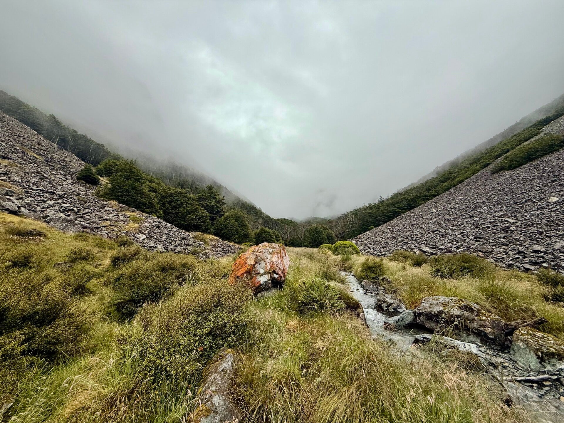
The trail then enters the misty forest, following a stream that babbles over rocks covered in thick moss. The route alternates between woods and scattered clearings, all bathed in a calm morning atmosphere. At the bottom of the slope, a narrow valley opens up, the slopes on both sides covered in scree that cascades down from the heights in the fog and stops at the grass, so that two scree slopes face each other, barely ten meters apart, with the trail running between them. Progressing through all the vegetation is not easy, the path winding through thick bushes, which attests to the trail not being well used; moreover, they are saturated with morning dew, and I am quickly soaked up to my shoulders.
At the bottom of the valley, the path joins the main Te Araroa trail. This section, to which we added an extension these last two days, stretches from the small village of Saint Arnaud to the Boyle River for about a hundred kilometers. I climb the gently sloping valley alongside a wide stream, passing two huts in succession, before tackling an 1100-meter ascent. The sky clouds over, a light drizzle begins to fall, but I can still see the surrounding mountains, only a portion of them obscured by clouds.
However, as I cross the pass, thick clouds completely obscured my visibility, and the rain begins to pour as I descend the other side for another 1300 meters. I am exhausted when I arrive at the hut for the night, but I managed to get there earlier than I had anticipated. Even Natalie, who had taken a shorter route than me, arrives after me, equally weary.
Dinner and off to bed!
🗓️ January 28, 2026
🏁 Kilometers : 2087
We wake up this morning to a pleasant surprise: a blue sky. It has been raining almost every day for a week… some Kiwis told us it is the worst summer they'd experienced in a long time. So, knowing we are having sunshine today is very motivating. Especially since we are going to climb the highest point of the entire Te Araroa trail, which is also one of the most beautiful sections. Randomly, it turns out today is our hundred’s day on the trail.
Natalie set off a little before me; I will catch up with her later in the day. The trail follows the Sabine River through the forest and climbs steadily for eight kilometers, the river gradually narrowing as we ascend through this narrow valley. Its waters gurgle constantly, a presence almost like a walking companion. The air is fresh and clean, dew drips from the vegetation, and the birds put on a show. It's hard not to appreciate this moment in the heart of nature, in harmony with this environment. It's been over three months since I started this long trek, living a more organic life than usual, doing almost everything outdoors: walking, eating, sleeping, washing… constant contact with nature stimulates certain instincts, surely buried deep within each of us, that our current way of life prevents us from experiencing. I feel at peace; the tension between past and future doesn't really matter here, nor even dates and times. I can know how the day will begin, but rarely how it will end, which is exhilarating.
The sun appears around 9:30 a.m., having been hidden behind the high mountains surrounding me until now. Its touch on my skin and its rays warming my clothes feel wonderful, especially after its absence for so long. My progress is slow today; I'm feeling tired from yesterday's long day. My glutes are burning, and my thigh muscles are screaming for help! But I don't need to cover a long distance today; I can stop anywhere along the trail as long as I find a place to pitch my tent.
Meanwhile, I reach the first hut around 11:00 a.m., where Natalie is also taking her break. Right next to it is the Blue Lake, which is off-limits, and even forbidden to touch. Studies conducted on the lake in 2011 showed that it has some of the clearest water in the world; this ecosystem is very fragile, hence the restrictions put in place to raise public awareness. As we continue along the trail and gain some elevation, we realize that the lake is indeed breathtakingly beautiful and crystal clear.
We have to climb a little further and then we arrive at a second, much larger body of water: Lake Constance. This lake was created by a gigantic landslide that literally blocked and flooded the valley floor. Located at an altitude of about 1,300 meters, it is surrounded by peaks exceeding 2,000 meters, whose scree-covered slopes plunge directly into the lake. Waterfalls cascading down the rocky escarpments add another layer of beauty to the already stunning scenery. We thank our lucky stars for the beautiful weather we've had today!
We have to go around the lake, and when we reach the most remote point of the valley, in the center of a cirque of peaks, we realize that we now have no other choice but to cross to the other side… with a good 500 meters of elevation gain awaiting us on a dizzyingly steep slope. My legs want to go on strike, but since I command them to keep climbing anyway, it takes me an hour and a half to cover barely a kilometer… I stop countless times, but since the views are breathtaking, let's just say I wanted to admire it every ten meters.
The pass is at 1850 meters altitude, and we discover a whole new valley stretching out before us. I love that moment when, in just a few seconds, we see a new landscape so beautiful it almost takes our breath away! Instantly, the 500 meters we had climbed have to be descended again; this time it is my knees that want to go to the complaints department. The descent is arduous and technical, but by taking our time, we avoid falls and protect our joints.
I arrive at the evening campsite, located at 1100 meters on a small, flat strip of short grass at the edge of the natural treeline, beside a river and surrounded by high mountains. I don't think I've ever pitched my tent in such a beautiful spot. I take off my clothes and dip into the river, the water colder than ever! We share dinner with Natalie and four other hikers who join us a little later.
What a beautiful day !
🗓️ January 29, 2026
🏁 Kilometers : 2121
The clouds returned overnight, and I wake up this morning to a gray sky, thankfully without rain. Today's route is following the Waiau Uwha River for 30 kilometers, requiring numerous fords.
At first, the trail closely follows the river, passing through small groves and scree slopes that stretch across entire hillsides. After a few kilometers, the trail disappears into meadows, with only a few markers indicating the approximate path to follow. Finding the next marker has become a game, as they are sometimes hundreds of meters apart; since I'm walking straight through a valley, I can't really get lost anyway.
Even though the sun, which usually adds vibrant hues to the landscapes, is absent, the scenery is sublime. I walk through a long valley devoid of any human presence, across vast fields of tall, yellowing grass. The surrounding mountains are fringed with forests that thrive only on the slopes, not in the flat part of the valley. The peaks are devoid of vegetation, their rocky summits dramatically striking. The river flowing through the middle sometimes confines itself to a narrow channel, sometimes spreading out into several shallow branches that create numerous meanders. The feeling of being alone here is intoxicating, and I feel the urge to listen to music and sing at the top of my lungs all afternoon.
I feel good, at home, exactly where I'm meant to be. My previous travel experiences had always left me with a slight aftertaste of something... to be clear, I'm not complaining; I've had many fantastic trips. But this adventure seems to be the most obvious, the most genuine, the one that truly resonates with me, the one that makes me feel like the pieces of the puzzle are finally fitting together.
At the end of the day, I had covered 34 kilometers, faster than I expected given that it was a flat terrain.One more day of walking and I would arrive in the evening in Hanmer Springs, a small tourist town known for its hot springs. I had been there with my siblings in 2020 during our trip to New Zealand, just three weeks before Covid.
It will bring back some wonderful memories.
🗓️ January 30, 2026
🏁 Kilometers : 2151
I wake up in my tent around 5:30 a.m. in the freezing cold. My tent is in a field at the bottom of a small hollow. I quickly pack up my things and set off to warm up. I have 30 kilometers left to reach the end of this section and the road where I can hitchhike to Hanmer Springs.
The trail continues its descent into the valley I had partially hiked up the day before, passing straight through fields saturated with morning dew where wisps of mist still linger. It then enters the forest, gaining some altitude, and forks to the left when I reach a low pass, leading to another valley that stretches almost in a straight line for about twelve kilometers, following another river. I can feel the accumulated fatigue of the previous days, and my pace is quite slow; my legs are heavier than ever. Rest will do me good.
After eight hours of hiking, I reach the end of the valley and can finally start hitchhiking. It takes me a good half hour and about fifty vehicles before one stops and gives me a lift. We are lucky enough to be staying with Samuel's family for the next three days. They welcome us as if we were part of the family, offering us dinner, and go out of their way to make sure we are comfortable.
Kiwi hospitality is extraordinary!
Photos from January 25 and 26, 2026


Photos from January 27, 2026


Photos from January 28, 2026


Photos from January 29, 2026


Photos from January 30, 2026


Add comment
Comments